2020 Vol. 42, No. 5

Display Method:
2020, 42(5): .
Abstract:
2020, 42(5): .
Abstract(388) HTML (32) PDF-CN(246)
Abstract:
2020, 42(5): 00-00.
Abstract(101) HTML (68) PDF-CN(8)
Abstract:
Evolution of global crustal uplift and subsidence and basins
KANG Yuzhu
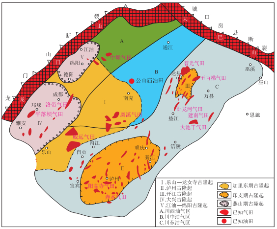
2020, 42(5): 653-661. doi: 10.11781/sysydz202005653
Abstract(910) HTML (90) PDF-CN(256)
Abstract:
The earth's crust is under various stresses including compressive stress, tensile stress and torsional stress, resulting in uplift, subsidence, depression and strike-slip. The tectonic movement caused uplifts and depressions in the crust, leading to changes in the land and sea. During the geological evolution history, the crust uplifted into orogenic belts or uplift areas, while depressions changed to various types of basins. Global basins can be divided into five major types, namely rift-craton, intracratonic depression, foreland, fault and depression ones. There are eight major deformation styles in the global structure, namely, east-west, north-south, north-east, north-north-east, north-west, epsilon-shaped, S- or reversed-S shaped, and twisted ones. Oil and gas in the Paleozoic cratonic basins of China are mainly distributed in paleo-uplifts, paleo-slopes, regional unconformities, and fault zones. In Mesozoic and Cenozoic faulted basins, oil and gas are mainly distributed in steep slopes, gentle slopes, and central structural belts. In Mesozoic and Cenozoic foreland basins, oil and gas are distributed in fault fold belts, slope belts and overthrust belts. Various twisted structures, such as broom-shaped, echelon, knob-shaped, reversed S-shaped, and λ-shaped ones, control oil and gas distribution.
There is no shortcut to find oil: some thoughts on oil and gas exploration
MA Yongsheng
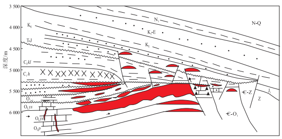
2020, 42(5): 662-669. doi: 10.11781/sysydz202005662
Abstract(1040) HTML (144) PDF-CN(348)
Abstract:
Explorers are the organizers, managers and practitioners of oil and gas exploration activities. They are also professionals who master petroleum geology and related disciplines, are familiar with exploration techniques, apply exploration methods flexibly, and are proficient in exploration management. So, they are both business and management experts. Successful explorers must first have a firm confidence in finding oil and gas, have a scientific spirit that does not blindly follow or agree, and always maintain a sensitivity of thinking. There are no shortcuts to exploration. First, we should solve the basic problems of exploration; second, we should adhere to scientific exploration procedures; third, we should have the awareness of development, efficiency, and dynamic optimization. We should highlight key points, and continue to optimize exploration deployment so as to ensure the completion of the exploration mission. To achieve high-quality exploration, the way of thinking should be changed from the traditional thinking of "heroes based on output" to that of "heroes based on benefits". The top-level design should be done to achieve the integration of investment, benefits and responsibilities, and further improve and establish the exploration deployment comparison and selection mechanisms and a new two-level decision-making management so as to achieve the "five major changes". With the rapid development of geophysical exploration technology and drilling and completion technology, current global oil and gas exploration is undergoing profound changes, and it is constantly developing into more detailed, deeper, broader, more difficult and more challenging fields. The faulted basins in East China, marine carbonate rocks, clastic rocks in Central and West China and shale gas will be the main areas for increasing oil and gas reserves and production. With advances in theory and technology, coalbed methane, shale oil, and oil shale are also important areas that need to be tackled and cultivated. In the future, with the rapid development of unconventional oil and gas theories, the basic system of oil and gas geology will continue to expand and improve. With the support of a new generation of intelligent technology systems for exploration and development, a conventional-unconventional overall evaluation and multi-layer exploration system of petroliferous basins will be formed, which will bring a new round of growth in oil and gas reserves and production.
Acquisition of "ZHU Xia's discussion on China's petroleum basin": Commemorating the 100th birthday of Mr. ZHU Xia
JIN Zhijun
2020, 42(5): 670-674. doi: 10.11781/sysydz202005670
Abstract(680) HTML (90) PDF-CN(198)
Abstract:
Mr. ZHU Xia is a petroleum geologist with profound attainments in theoretical science and an oil and gas prospector with rich practical experience. He is one of the pioneers of petroliferous basin research and one of the founders of petroleum geology in China. This article gives a brief review of Mr. ZHU Xia's core academic thoughts, and summarizes a series of innovative work methods and understanding put forward by some domestic scholars in studying, inheriting and developing Mr. ZHU Xia's academic thoughts in the past 30 years, including the author's works in basin evolution processes and hydrocarbon accumulation system analyses. Looking forward to the future, it is pointed out that the key scientific issues facing petroleum geology include the global and China's special geological background. It will definitely contribute to the development of China's petroleum geology theory and practice by studying, inheriting and developing Mr. ZHU Xia's academic thoughts.
Marine petroleum exploration in South China
GUO Xusheng, HU Dongfeng, DUAN Jinbao
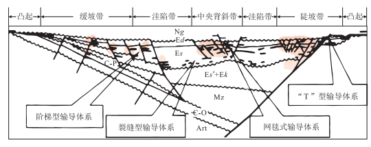
2020, 42(5): 675-686. doi: 10.11781/sysydz202005675
Abstract(1123) HTML (118) PDF-CN(266)
Abstract:
Marine strata in South China are mainly distributed in the Paleozoic and Mesozoic. The strata are old and the thermal evolution degree is high. It was controlled by the multi-cycle sedimentary and multi-stage structural evolution history. The petroleum basic geological conditions are superior, but the distribution of oil and gas is complicated. Oil and gas exploration has mainly gone through three stages: general survey, structural reservoir, massive lithologic gas reservoir and shale gas exploration. Although major breakthroughs have been made in many fields, the overall detection rate is low. A systematic summary of the early discovery of large gas fields and the new progress of exploration was made in order to clarify the prospects for oil and gas exploration. There is a large potential for marine petroleum exploration in South China. Deep and ultra-deep strata as well as new areas are important breakthrough directions in the Sichuan Basin. The unconventional shale gas reservoirs in the Upper Ordovician Wufeng-Lower Silurian Longmaxi formations and the conventional gas reservoirs in the platform margin zone of the Upper Sinian Dengying Formation in Langzhong-Yuanba, the platform inner beach facies in the Sinian-Cambrian in Tongnanba, the pre-salt strata in the lower assemblage in Qijiang in the southern Sichuan and the reef beach facies in the Permian-Triassic have a total resource amount to trillions of cubic meters, which is expected to achieve a new round of breakthroughs and discoveries. Besides, unconventional shale gas in the Permian and Jurassic and some new targets for conventional gas such as hydrothermal dolomites, karst fissure group, stucco limestones and sedimentary tuffs in the Permian show a great exploration potential. New discoveries continue to be made in complex basin-margin regions in the Sichuan Basin. Shale gas in the residual syncline area and conventional piedmont areas in the basin margin are the main exploration directions. The periphery of ancient uplifts and the progressive deformation area in the southern periphery have weak structural deformation, and the preservation conditions are favorable with a certain exploration potential, and are expected to become a strategic succession area for oil and gas.
Mesozoic and Cenozoic diktyogenese in the Lower Yangtze region
DING Daogui, LI Fengli
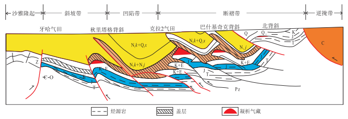
2020, 42(5): 687-697, 876. doi: 10.11781/sysydz202005687
Abstract(798) HTML (140) PDF-CN(182)
Abstract:
Three stages of metamorphic tectonic movements took place in the Lower Yangtze region due to the joint action of the Tethys and the Pacific plates from the Middle/Late Triassic to the Early/Middle Jurassic, the Late Jurassic to the Early Cretaceous, and the Late Cretaceous to the Tertiary. They made the Paleozoic basin basements undergo detachable progressive deformations, and formed foredeep basins in the Upper Triassic and Middle/Lower Jurassic. The translational strike-slip of a large-scale fault zone formed pyroclastic pull-apart basins in the Upper Jurassic-Lower Cretaceous. The Upper Cretaceous-Tertiary semi-graben basins, which are arranged in a domino style, are extensional basins formed by lithospheric extension and detachment structures. The three transformations promoted the formation, accumulation and redistribution of oil and gas.
Enrichment characteristics and resource potential of continental shale oil in Mesozoic Yanchang Formation, Ordos Basin
FU Suotang, YAO Jingli, LI Shixiang, ZHOU Xinping, LI Mingrui
2020, 42(5): 698-710. doi: 10.11781/sysydz202005698
Abstract(1061) HTML (247) PDF-CN(258)
Abstract:
The Chang 7 Member of the Mesozoic Yanchang Formation in the Ordos Basin mainly developed as a semi-deep to deep lacustrine mudstone and shale.It is the main oil-rich source bed for the Mesozoic reservoir in the basin. Compared with North American marine shale oil, the Chang 7 shale oil has diverse sedimentary facies, poor stratigraphic continuity and strong reservoir heterogeneity, and its enrichment and distribution characteristics are more complicated. The fine scale core descriptions of the Chang 7 Member from more than 30 wells and the experimental testing and analysis of more than 30 000 samples were carried out. The basic geological characteristics and main factors controlling enrichment of shale oil in the Chang 7 source beds were clarified, and the shale oil resource potential was evaluated. A major breakthrough was made in the Chang 7 Member shale oil exploration, and the Qingcheng Oilfield, a 1 billion ton large shale oil field, was discovered in 2019. There are three types of shale oil in the Chang 7 Member of Yanchang Formation, including the source-reservoir differentiation type (type Ⅰ), the source-reservoir integration type (type Ⅱ) and the pure shale type (type Ⅲ). The hydrocarbon source rocks with high abundance of organic matter provides the material base for the enrichment of shale oil, the sandstone reservoirs have numerous micro pores and nano throats, which are the main spaces and seepage channels for shale oil. The inter-distribution of multiple types of fine-grained sediments constitutes a good source-reservoir configuration, and high-intensity hydrocarbon charging and abnormal high pressure form reservoirs with high saturation in source rocks. The Chang 7 Member developed in the Longdong and northern Shaanxi shale oil-bearing areas, and the shale oil reserves have been initially estimated to be 3 to 5 billion tons, showing great exploration and development potential. By 2025, a production base of 5 million tons is expected.
A review of the Late Mesozoic magmatic arc in Borneo with slab subduction models
XU Changhai, ZHU Weilin, LIAO Zongting
2020, 42(5): 711-719. doi: 10.11781/sysydz202005711
Abstract(675) HTML (103) PDF-CN(157)
Abstract:
Borneo is at the critical junction of two tectonic domains. The Schwaner magma arc and the Meratus and Lupar subduction complexes are the prominent features of Borneo in the Late Mesozoic, which result from the subduction of Tethys or/and paleo-Pacific domains. The current research level of Mesozoic geology in Borneo is not high. The lack of combined studies of geology, geochemistry and geophysics, and the lack of comparative studies in the region around South China Sea areas have restricted the overall understanding of Borneo's magmatic arc evolution and slab subduction model. The Late Mesozoic magmatic arc in Borneo is either related to the northwestward subduction of the Meso-Tethys slab, or the southward subduction of the proto-South China Sea slab, or possibly both, controled by the Tethys and paleo-Pacific domains. The pre-Cretaceous tectonic affinity of SW Borneo is either with the Cathaysia block or as a fragment of the eastern Sundaland, or it may be an exotic block from the Gondwana continent. The combination from sea to land, and the multidisciplinary, regional, comprehensive, and comparative research should be strengthened in the future, focusing on magmatic arc, ophiolite, subduction complex, regional fault, and Mesozoic basins, etc. These help to trace the evolved geodynamic controls of the Late Mesozoic continental margin in Borneo by Tethys or/and paleo-Pacific slab subduction. It will deepen the regional understanding of the Late Mesozoic arc-basin system, basin prototype, and oil and gas exploration and potential in areas of the South China Sea.
The prototype basin and its nomenclatures and research
LIU Chiyang, WANG Jianqiang, ZHAO Xiaochen, HUANG Lei, ZHANG Dongdong, ZHAO Junfeng, DENG Yu, MA Huanhuan
2020, 42(5): 720-727. doi: 10.11781/sysydz202005720
Abstract(861) HTML (180) PDF-CN(178)
Abstract:
The prototype basin has become a hot nomenclature, which is widely used in the geoscience field. However, in a large number of publications, the understanding and expression of the prototype basin are quite different. Based on the analyses of the published and intramural documents, we believe that the prototype basin was newly defined by ZHU Xia in 1982, proposing that the prototype basin refers to a structural form and sedimentary entity formed in a geodynamic context (environment) during a certain geological history. A simple (small scale) basin is a prototype basin, and a large complex basin always contains several different prototype basins, which means the prototype basin varies over time. The nomenclature of the prototype basin should be an important part of ZHU Xia's academic thought and scientific theoretical system, which has a specific scientific connotation and nomenclature. It is suggested that the prototype basin and its synonymous nomenclature should be used in specific contexts for those basins whose original conditions have not been obviously transformed in the course of basin development. The original conditions contain the formation, evolution and hydrocarbon accumulation (mineralization) and several other related aspects of the basin. It is very difficult to reconstruct a reformed basin and get its prototype due to the complicated formation process, complex late reformation and uncertainty of reconstruction evidence and interpretations. The key points to reconstruct the original basin or the prototype basin can be summarized as: searching the evidence, determining the basin attributes, modeling the original state and remodeling the process, all of which need to be interrelated and carried out step-by-step.
Paleozoic basin prototype evolution and source rock development in the South Yellow Sea
ZHU Weilin, CHEN Chunfeng, ZHANG Bocheng, WAN Yanzhou, FU Xiaowei, ZHANG Yinguo
2020, 42(5): 728-741. doi: 10.11781/sysydz202005728
Abstract(929) HTML (185) PDF-CN(145)
Abstract:
Drill samples and outcrops confirmed that three sets of source rocks developed in the Lower Yangtze Block area, namely, the Lower Cambrian Mufushan Formation, the Upper Ordovician Wufeng Formation-the Lower Silurian Gaojiabian Formation, and the Permian. This tectonic environment determined the evolution of the basin, which then affected the distribution of lithofacies and source rocks. During the deposition of the Lower Cambrian Mufushan Formation, the South Yellow Sea Basin was a passive continental cratonic margin basin undergoing regional extension. The basin facies and deep-water shelf facies developed around the paleo-uplift or platform, which were the dominant facies for the development of source rocks. It was predicted that this set of source rock developed well in the Middle Uplift and the northern part of the South Yellow Sea Basin. During the depositing of Wufeng and Gaojiabian formations, the South Yellow Sea Basin was a compressional foreland basin. The basin facies, slope facies and deep-water shelf facies were distributed in strips from the northwest to the southeast of Lower Yangtze area. The basin facies and deep-water shelf facies were dominant facies in which source rocks developed well. It was predicted that the source rocks of Wufeng-Gaojiabian formations were distributed mainly in the middle and north part of the South Yellow Sea Basin. During the deposition of the Upper Permian Longtan Formation, the South Yellow Sea Basin experienced active continental margin convergence. The sedimentary facies in the basin were scattered in ring belts. Delta and tidal flat facies were dominant with moderate to good quality source rocks. It was predicted that the source rocks of the Longtan Formation developed in the middle part of the South Yellow Sea Basin, which was the secondary source rock of Paleozoic in the South Yellow Sea Basin.
TSM prototype basins on the Neoproterozoic Yangtze Craton
YANG Fengli, ZHOU Xiaofeng, HU Yuyang, YANG Ruiqing, PENG Yunxin
2020, 42(5): 742-755. doi: 10.11781/sysydz202005742
Abstract(808) HTML (174) PDF-CN(147)
Abstract:
TSM basin analysis of Neoproterozoic prototype basins on Yangtze Craton, South China were studied using a large number of field outcrop sections, latest drilling data, and numerous previous studies. Controlled by the Qingbaikou convergent continental margin to the Nanhua-Sinian divergent continental margin, four phases of basin evolution are identified in the Neoproterozoic Yangtze Craton: a) the early Qingbaikou period(ca. 1 000-820 Ma), with back-arc spreading basins on the western and northern Yangtze margins and the interior, and a retro-arc foreland basin on the southeastern Yangtze margin; b) the late Qingbaikou period (ca.820-720 Ma), with back-arc spreading basins on the western and northern Yangtze margins and extensional down-faulted basins on the southeastern Yangtze margin and the interior of the carton; c) the Nanhua period (ca.720-635 Ma), with rift basins on the southeastern, western, and northern Yangtze margins and the interior; and d) the Sinian period (ca. 635-541 Ma), with intracratonic rift basins in the interior of Yangtze Craton (i.e. the central Sichuan, the Wanyuan-Dazhou and the west Hubei-east Chongqing area) and divergent marginal subsidence basins on the southeastern and northern Yangtze margins. The Nanhua rift basins and the Sinian divergent marginal subsidence and intracratonic rift basins were most conducive to source rock formation. The southern Shaanxi, northeastern Sichuan, western Hubei, central Sichuan and the adjacent area of Hunan, Guizhou and Chongqing are the most favorable areas of the Neoproterozoic source rocks in the Yangtze Craton. They are also considered to be favorable regions for deep natural gas exploration on the Yangtze Craton.
Provenance analysis of Sinian sediments on the northwestern margin of Tarim Basin and its restriction on basin types
CHEN Hanlin, HUANG Weikang, LI Yong, ZHANG Fengqi, WU Hongxiang, YANG Zhilin, HUANG Shaoying, YANG Shufeng
2020, 42(5): 756-766. doi: 10.11781/sysydz202005756
Abstract(759) HTML (108) PDF-CN(171)
Abstract:
The Neoproterozoic is a very important stage in the global tectonic evolution, which experienced the amalgamation and break-up of the Rodinia. The Nanhua and Sinian strata in the Tarim Basin, which is one of the three major craton basins, have recorded a great deal of information about the tectonic attributes and plate dynamics of the basin in the Neoproterozoic. These are also the key strata for deep oil and gas exploration in the Tarim Craton Basin. Based on field investigations and studies of sedimentary characteristics, this paper studies the U-Pb dating of detrital zircons and provenance of sediments from the Sinian strata outcropped on the northwestern margin of the Tarim Basin. The age distribution of detrital zircons from the Sugetebrak Formation have five peaks in age of about 2 600, 2 300, 2 000-1 800, 790-730 and 620 Ma. The detrital zircons with peak ages of 2 600, 2 300 and 2 000-1 800 Ma are from the Neoarchean-Mesoproterozoic basement within the Tarim Craton, the detrital zircons with peak ages of 790-730 Ma may be derived from magmatic rocks formed by rifting during the late Neoproterozoic in the Tarim Basin, and the zircons with a peak age of 620 Ma were directly derived from magmatism at the time of formation deposition. These results suggest that the clastic material may have originated in the Tarim Basin itself. In view of the fault depression to depression structure on seismic profile, the rapidly filled turbidite sedimentary construction in the Nanhua strata, the transformation of Sinian strata from a clastic rock sequence to a marine carbonate sequence, and the magmatism during the sedimentary period of the Sinian Sugetebrak Formation, it is concluded that the northwestern margin of the Tarim Basin experienced the transition from fault-depression to rift subsidence during the Sinian.
Deep geological processes and deep resources in basins: scientific issues and research directions
HE Zhiliang, LI Shuangjian, LIU Quanyou, YANG Tianbo, ZHANG Ying
2020, 42(5): 767-779. doi: 10.11781/sysydz202005767
Abstract(962) HTML (143) PDF-CN(215)
Abstract:
Marching deeper into the earth is of great significance for domestic resource strategy and tends to be an inevitable research direction in geoscience. With theoretical and technological progress achieved in recent years, hydrocarbon resources in deep or ultra-deep reservoirs have become a major exploration field for targets at home and abroad. Various discoveries of large-scale geological resources, such as H2, He, CO2 and geothermal resources, are proved to be related to deep geological processes, and therefore it is important to reveal the impact of these on deep accumulations. In this paper, the effects of basinal deep processes on hydrocarbon generation and evolution of source rocks, formation and preservation of reservoirs, migration and accumulation of hydrocarbon and its associated resources were discussed. Besides, some research progress and key scientific issues were summarized, and subsequently several research directions were proposed. Presently main scientific issues regarding deep geological processes and deep resources include: a) chemical kinetic models and multiple hydrocarbon generation potential of source rocks in deep geological processes; b) interaction mechanism of water-rock-hydrocarbon in high-pressure and high-temperature supercritical systems and effectiveness of ultra-deep reservoirs; c) phase transformation, accumulation and preservation of hydrocarbon in deep oil and gas systems; d) generation and accumulation of hydrocarbon-associated resources in specific deep geological environments. To carry out research on deep geological processes and deep hydrocarbon resources, it is necessary to start with the geological evolution of sedimentary basins, centering on the key issues of deep geological processes and resource effects and taking typical basins with active deep fluids as research objects, and revealing the mechanism of physical and chemical functions of deep formation, finally clarifying the impact of deep geological processes on the formation and accumulation mechanism of deep resources (oil and gas, H2, CO2, He, geothermal resources and hot dry rocks) and exploring the frontiers of deep resources. The main research directions in the future include: a) deep geodynamic settings and mechanism of geological processes; b) deep hydrocarbon generation kinetics and quantities; c) formation and preservation mechanisms of deep reservoirs; d) migration and accumulation mechanisms of deep hydrocarbons; e) differential enrichment mechanism of deep hydrocarbon-associated resources. Based on the above research, the accumulation theories and evaluation methods of hydrocarbon under the influence of deep geological processes were improved, and some scientific evidence for the exploration and evaluation of deep hydrocarbon-associated resources were provided.
Formation and evolution of Yin'gen-E'ji'naqi Basin and prospects for oil and gas exploration
ZHANG Hong'an, LI Jidong, WANG Xuejun, SHI Dahai, CHEN Qingtang, FAN Xiaoli, SI Minna, ZHAO Qiang
2020, 42(5): 780-789. doi: 10.11781/sysydz202005780
Abstract(626) HTML (84) PDF-CN(172)
Abstract:
The Yin'gen-E'ji'naqi Basin is located in the central and western part of the Inner Mongolia autonomous region, with an area of about 123×103 km2. It is a continental rift basin with a low exploration degree in North China. Due to the influence of complex surface and underground conditions, only the geological characteristics of the Chagan, Tiancao, Hari and other sags around the basin were studied during the early stage, which proved that each sag had the conditions for oil and gas accumulation, but the overall exploration potential was low. In recent years, on the basis of previous studies and combined with more field geology surveys, seismic and drilling data, the formation and evolution of the basin and the resource potential were re-evaluated. The Yin'gen-E'ji'naqi Basin basement was formed from the end of Permian to the Early Triassic, mainly composed of accretion-collision mélange, with moderate-shallow metamorphism generally occurring. Since the Mesozoic, affected by the Yanshanian and Himalayan movements, the basin has undergone six stages of structural evolution, with the characteristics of residual and reformed basins. The remaining Lower Cretaceous Bayin Gobi Formation is mainly distributed in the central and northern part of the basin, and is the main hydrocarbon generation and reservoir system. The total resources of the basin are estimated to be about 1.364 billion tons. Under the influence of strong late transformations, preservation conditions are the key factors for hydrocarbon accumulation. The tectonic activities in the northern part of the basin are relatively weak, and the effective source rocks in Bayin Gobi Formation remain in the depression area, which is the development area of overpressure oil and gas reservoirs and has become the key area for further exploration.
Research progress and challenges of thermal history reconstruction in sedimentary basins
QIU Nansheng, HE Lijuan, CHANG Jian, ZHU Chuanqing
2020, 42(5): 790-802. doi: 10.11781/sysydz202005790
Abstract(695) HTML (114) PDF-CN(218)
Abstract:
The current status and development of the methods of thermal history reconstruction in sedimentary basins are introduced systematically in this paper. The reconstruction methods of thermal history of sedimentary basins mainly include thermal indicators and geodynamic methods. The former mainly considers thermal history at the basin scale; however, the latter uses thermal history of the basin on the scale of the lithosphere. Thermal indicators mainly include the maturity index of organic matter and low temperature thermochronology parameters. The thermal indicator method is considered to be feasible with high precision, because the simulation results can be verified by measured data. In actual work, a variety of thermal indicators are generally used to couple the inversion of thermal history to improve the accuracy and reliability of the simulation results. For basins with various tectonic evolution stages, the thermal indicator method and the geodynamic method can complement and verify each other, thereby realizing quantitative restoration of the complex thermal history of ancient basins. At the same time, the thermal history of basins provides an important method and technology for the study of shale gas preservation during tectonic uplift and basin-mountain tectono-thermal evolution coupling. At present, there are still many problems and challenges in the reconstruction of thermal history of deep and ultra-deep strata, marine strata and ancient strata.
Formation conditions and exploration direction of large and medium oil and gas reservoirs in Xihu Sag, East China Sea
ZHOU Liqing, JIANG Donghui, ZHANG Shanghu, ZHOU Xinghai, YANG Pengcheng, LI Kun
2020, 42(5): 803-812. doi: 10.11781/sysydz202005803
Abstract(741) HTML (97) PDF-CN(173)
Abstract:
A low exploration success ratio on the Baochu Slope of Xihu Sag of East China Sea has been inferred, and the ratio in the Central Anticline Belt varies significantly in different sub structures. To solve this issue, the petroleum geologic conditions of the sag were systematically reviewed in light of new basin analysis methodologies, and new understanding have been achieved. Due to the differences in tectonic features and evolution histories, the Baochu Slope and Central Anticline Belt developed different petroleum systems and play types. Only those areas with overlapping favorable fairways of all petroleum system elements promise the formation of large oil and gas fields. The Baochu Slope is featured by tectonic rifting, with weak later compression and early structure formation. Its favorable conditions for hydrocarbon accumulation include: short distance to the main source kitchen; multiple, overlapping, large-scale reservoirs; multiple structural-stratigraphic trap types; good vertical sealing zones; and effective lattice pattern migration pathways. The large to medium structural-stratigraphic fields are concentrated in fairways with a large scale source kitchen and updip pinchout of tide-dominated delta sands controlled by paleo slope break which in turn were induced by either faulting or paleo morphology. The Central Anticline Belt has experienced strong inversion and compression during the late depression stage, and developed inverted compressional slip faults and large scale anticlines. Hydrocarbon accumulation is controlled by four major factors: preexisting structural highs before the compressional event, large scale structural-lithological traps, excellent timing of hydrocarbon charging during deformation, and highly effective reservoir-seal combinations. The areas with good congruence of these contro-lling factors promise the occurrence of large-scale deposits such Longjing, Guzhenzhu, Huxinting fields.
CNPC oil and gas resource potential and exploration target selection
HU Suyun, LI Jianzhong, WANG Tongshan, WANG Zecheng, YANG Tao, LI Xin, HOU Lianhua, YUAN Xuanjun, ZHU Rukai, BAI Bin, ZHUO Qingong
2020, 42(5): 813-823. doi: 10.11781/sysydz202005813
Abstract(858) HTML (171) PDF-CN(249)
Abstract:
Exploration and development of oil and gas is becoming increasingly difficult, and exploration targets and resource occurrence conditions are becoming more complex. Therefore, it is urgent to clarify the current situation and challenges of oil and gas exploration to evaluate the potential of domestic conventional and unconventional oil and gas resources, to illuminate the distribution characteristics of the remaining oil and gas resources, to evaluate and implement key exploration areas and favorable exploration zones, and to consolidate domestic oil and gas resources. In face of the new situation and new requirements, China National Petroleum Corporation (CNPC) has proposed five measures to strongly support oil and gas exploration. They have made 10 strategic discoveries and 10 major breakthroughs, and explored 15 large-scale reserves distributed in the central and western regions in China. Furthermore, proven reserves of oil and gas continued to grow at a high level. In this study, we summarized the oil-and-gas exploration situation, challenges and important measures of CNPC in the past ten years, and analyzed the potential and distribution of CNPC remaining oil and gas resources. The key areas and directions for oil-and-gas explorations of CNPC were discussed. It is indicated that the four areas of deep marine carbonate, lithologic strata, the lower reservoir-forming combination in the foreland thrust belt and shale oil are still the key points for breakthrough discoveries of future oil and gas exploration and large-scale reserves growth.
Hydrocarbon sources controlled by basin prototype and petroleum accumulation controlled by basin superposition: thoughts and technology of resource grading evaluation and exploration optimization in petroliferous basins
XU Xuhui, FANG Chengming, LU Jianlin, JIANG Xingge, WANG Baohua, LIANG Yusheng
2020, 42(5): 824-836. doi: 10.11781/sysydz202005824
Abstract(727) HTML (132) PDF-CN(253)
Abstract:
The formation and evolution of petroliferous basins in China are characterized by multi-cycles, multi-genesis, multi-stages and superposition. In these basins with their own style and characteristics, based on the analysis of 3T (time, tectonic setting, thermal regime)-4S (subsidence, sedimentation, stress, style)-4M (material, maturation, migration, maintenance) proposed by Mr. ZHU Xia, and the research and practice of a large number of basins in eastern and western China, a basin analysis and evaluation of "prototype controlled sources and superposition controlled accumulation" is summarized, a "3342" (3 controls, 3 evolutions, 4 effects and 2 centers) analysis method is proposed, and a TSM basin simulation and resource evaluation system is developed. These methods and systems play an important guiding role in the analysis, research and exploration evaluation deployment of different exploration stages and types of basins in China.
Progress and direction of exploration and development of normally-pressured shale gas from the periphery of Sichuan Basin
GUO Tonglou, JIANG Shu, ZHANG Peixian, ZENG Ping
2020, 42(5): 837-845. doi: 10.11781/sysydz202005837
Abstract(690) HTML (71) PDF-CN(302)
Abstract:
This study firstly introduces the geology and production characteristics of the typical normally-pressured shale gas plays in the U.S. and analyzes the origins of normal pressure and under-pressure. The normally-pressured shale gas reservoirs from the periphery of Sichuan Basin are then characterized using the E & P cases of the Upper Ordovician Wufeng to Lower Silurian Longmaxi formations in the Wulong, Pengshui and Daozhen areas. The comparison between normally- and under-pressured shale gas reservoirs in the U.S. and China reveals that: (a) U.S. shales with large thickness are widely distributed; (b) U.S. shales have relatively lower maturity compared to Chinese marine shales; and (c) U.S. shales experienced fewer tectonic events after deposition. Nitrogen foam and ultra-light proppant have been successfully used for the hydraulic fracturing of the under-pressured Ohio shale in the Big Sandy area. Based on the analysis of the exploration and development progress of three residual synclines, it is apparent that the tectonic period and strength, burial depth and distribution area are the main factors for the difference of preservation conditions of residual synclines outside the basin, and are also the main reasons for the difference of formation pressure coefficient and production. Based on this, the paper puts forward some suggestions for further theoretical and technical research on normally-pressured shale gas from the periphery of the basin.
Advance of basin modeling key techniques: hydrocarbon migration and accumulation simulation
GUO Qiulin, CHEN Ningsheng, LIU Zhuangxiaoxue, LIU Jifeng, YU Jingdu
2020, 42(5): 846-857. doi: 10.11781/sysydz202005846
Abstract(886) HTML (121) PDF-CN(316)
Abstract:
This paper summarizes traditional basin modeling, points out new application fields and technical problems, and discusses the present situation and progress of three kinds of hydrocarbon migration and accumulation simulation techniques.(a) Flowpath modeling. Evolved from reservoir numerical simulation, this technology is rapid and is suitable for structural reservoirs; however, it cannot effectively simulate stratigraphic reservoirs.By establishing a simplified 3D geological model, the description of 3D trap space and reservoir physical properties is realized and the problem of stratigraphic reservoir simulation is solved, and the leap of streamlined simulation technology is realized.(b) Invasion percolation. It is now practical, but the description of fault, unconformity surface and other transport systems under complex geological conditions is not detailed enough to assign parameters to the fault or unconformity surface alone.The 3D mesh modeling method of transport systems and 3D path tracing technology based on a Mesh System can effectively analyze the oil-gas migration path, simulate the process of oil-gas accumulation, reservoir adjustment and secondary reservoir formation, and improve the technology greatly.(c) 3D Darcy flow. This is the most advanced technology in theory, but it is difficult to constrain the geological parameters with sufficient precision. Therefore, improving the geological grid model and accurately describing the geological parameters are important in the development of a 3D Darcy flow model. Establishing a 3D geological model of the bedding columnar PEBI (Perpendicular Bisection) grid, constructing the seepage equation under the condition of variable grid, and introducing vector permeability, can solve the seepage problem under complex geological conditions, and improve the simulation technology.
Gas resources and accumulation model of BZ19-6 Archean buried-hill large-scale gas reservoir in Bozhong Sag, Bohai Bay Basin
XIE Yuhong
2020, 42(5): 858-866. doi: 10.11781/sysydz202005858
Abstract(918) HTML (132) PDF-CN(260)
Abstract:
Traditionally the Bohai Bay Basin is prone to oil rather than gas pooling because it is dominated by lacustrine mudstones. Factors such as the development of young structural faults are not conducive to natural gas accumulation and preservation. Based on the understanding of the dynamics, evolution, and sedimentary filling characteristics of the Bozhong Sag in the Bohai Sea area, a thermal simulation of source rock evolution and gas generation rate was carried out. Under the background of rapid hydrocarbon generation in oil-rich basins, the reservoirs in the secondary gas generation stage have the hydrocarbon generation intensity to form large natural gas reservoirs during deep burial. The regionally distributed thick Paleogene overpressure mudstones not only prevent the loss of natural gas, but also provide the drive for natural gas migration and charging. Research on fluid inclusions shows that the Bozhong Sag has generally experienced the accumulation of early oil and late gas. The BZ19-6 buried hill structure has formed a large-scale high-abundance condensate gas reservoir due to multiple sources of high-intensity gas generation, rapid and strong charging close to the hydrocarbon source, and thick mudstone overpressure sealing. The understanding and successful discovery of the BZ19-6 condensate gas field has broken through the understanding that it is difficult to find large gas fields in oil-rich basins, expanded the field of natural gas exploration, and is important for natural gas exploration in deep buried ancient metamorphic buried hills and active fault zones.
Carbonate reservoir forming model and exploration in Tarim Basin
QI Lixin, YUN Lu
2020, 42(5): 867-876. doi: 10.11781/sysydz202005867
Abstract(805) HTML (123) PDF-CN(303)
Abstract:
The understanding of oil and gas accumulation patterns is closely related to exploration ideas and directions. Through the exploration results and knowledge review of the Tarim Basin, a hydrocarbon accumulation model in the Tarim Basin has been established and a transformation of exploration ideas and knowledge has been demonstrated. Buried hill structure model transformed to paleo-uplift (paleo-slope) karst fracture-cavity model. By analyzing the accumulation conditions and characteristics, a "paleo-uplift and paleo-slope karst fracture-cavity complex reservoir formation model" was established in the Tahe Oilfield providing a marine carbonate oil and gas accumulation model in the Tarim Basin. The discovery and expansion of the Shunbei oil and gas field is related to the establishment of the "super deep fault-karst complex accumulation model", which has achieved spatial expansion and an exploration breakthrough from the paleo-slope to the "forbidden area" in the lower location. Analysis of an ultra-deep fault-karst oil and gas reservoir provided the basis for a model of an uplift-slope + hinterland fault-karst of the platform basin in the Tarim Basin. The complete marine hydrocarbon accumulation model has enhanced the theory of marine carbonate oil and gas accumulation in China and pointed out a direction for future oil and gas exploration.
2020, 42(5): 877-877.
Abstract(388) HTML (12) PDF-CN(377)
Abstract: