2022 Vol. 44, No. 6

Display Method:
2022, 44(6): .
Abstract:
Dynamic difference and characterization of reservoir fluid in continental rift basins
ZHANG Shouchun, WANG Xuejun, WANG Xiuhong, ZHU Rifang, QIU Yibo
2022, 44(6): 941-949. doi: 10.11781/sysydz202206941
Abstract(433) HTML (76) PDF-CN(166)
Abstract:
In order to establish the relationship between hydrocarbon characteristic variations and dynamic environments, the differences of hydrocarbon geochemical characteristics of reservoirs in various pressure systems (overpressure zone, transitional pressure zone and normal pressure zone) were studied. The Dongying and Zhanhua sags in the Jiyang Depression of the Bohai Bay Basin were taken as examples in this paper, the variations of sterane isomerization parameter, sterane light/heavy ratio with depth were revealed. The transition from overpressure charging to normal pressure driving was clarified. The typical profiles of the Boxing (single pressure structure) and Bonan (composite pressure structure) sub-sags in the Dongying and Zhanhua sags, respectively, were selected for the differential analyses of geochemical parameters and corresponding dynamic conditions in various belts. The variations of the geochemical parameters showed high correlations to overpressure driving and buoyancy driving. The development ranges of abnormal pressure during reservoir formation were studied as well, which are much larger than the present abnormal pressure distribution ranges. Especially in the step-fault zone belt, historic overpressure had greatly extended outwards. According to the geochemical characterization of dynamic conditions, the reservoir formation systems and hydrocarbon supply ranges were described in detail.
Differences in oil and gas enrichment in slope belts of rift basins and main controlling factors for hydrocarbon accumulation: a case study of Sanhe Sub-sag in Jinhu Sag, Subei Basin
HUA Zuxian, LIU Xiaoping, SUN Biao, LIU Tian, LIU Jie, LIU Qidong, LIU Shili, BI Tianzhuo
2022, 44(6): 950-958. doi: 10.11781/sysydz202206950
Abstract(568) HTML (179) PDF-CN(102)
Abstract:
The slope zone of rift basin is close to the hydrocarbon generation center of deep depression zone, and is favorable area for oil and gas accumulation. Due to the heterogeneity of the development of fault and sedimentary system in slope zone, oil and gas accumulations often show obvious heterogeneity, and the degree and scale of oil and gas enrichment on the plane are different. The oil and gas accumulation of the second member of Funing Formation (E1f2) in the slope belt of Sanhe Sub-sag of Jinhu Sag of Subei Basin is characterized by rich in the south and poor in the north, and the hydrocarbon accumulation is controlled by multiple factors. Geochemical test and logging data interpretation showed that the southern part has better source conditions than the northern part in the study area. Three types of source-reservoir configurations were developed vertically: lower-sourced and middle-reserved, self-sourced and self-reserved, as well as upper-sourced and lower-reserved, among which the type of upper-sourced and lower-reserved is the most developed and has the most enriched oil and gas in the studied area. On the plane, there are three types of source-reservoir configurations: stacked source-reservoir type, source-reservoir adjacent type, and source-reservoir separated type. The northern part of the study area is dominated by the source-reservoir separation type, while the southern part is dominated by the stacked source-reservoir type and the source-reservoir adjacent type. The southern part of the study area has well-developed fault system, abundant provenance and sand bodies, while the northern part is far away from provenance and has underdeveloped sand bodies. It is concluded that the superior hydrocarbon source conditions, appropriate source-reservoir configurations and good transport system are the key factors controlling the enrichment of oil and gas in faulted basins.
Petroleum geological conditions and exploration potential of the Permian Qixia Formation in the middle segment of Western Depression, Sichuan Basin
ZHANG Zhuang, SU Chengpeng, SONG Xiaobo, SHI Guoshan, WANG Renfu, LI Suhua, DONG Xia, HU Yongliang
2022, 44(6): 959-970. doi: 10.11781/sysydz202206959
Abstract(321) HTML (105) PDF-CN(86)
Abstract:
In recent years, great breakthroughs have been achieved for the exploration in the Permian Qixia Formation of the Shuangyushi structure in the north and the Pingluoba structure in the south of the Western Depression of the Sichuan Basin (Chuanxi Depression), while the exploration of the same formation in the middle segment of the Chuanxi Depression has not been carried out. In order to accelerate the ultra-deep marine natural gas exploration of the Qixia Formation, based on a large number of outcrops around the middle segment of the Chuanxi Depression, combined with seismic and drilling data and previous research results, this study systematically combed the oil and gas geological conditions of the Qixia Formation and comprehensively analyzed its exploration potential. Results show that the Qixia Formation in the study area has comparable sedimentary background as the north and south segments of the Chuanxi Depression, and is a platform margin sedimentary facies with superior reservoir conditions. Moreover, the Qixia Formation in the study area is connected with the hydrocarbon generation center of the Cambrian Qiongzhusi Formation by source faults. The tight limestone and shale of Permian and the gypsolyte of Triassic can be potential excellent cap rocks. Therefore, the source-reservoir-cap assemblage of the Qixia Formation in this area is preferential for large-scale hydrocarbon accumulation.
Imbibition characteristics and influencing factors of reservoirs with ultra-low permeability of Ordos Basin: a case study of third member of Triassic Yanchang Formation in Weibei Oil Field
LI Ming, LIAO Jing, WANG Su, HE Zixiao, WANG Huiwei, WANG Jun, HE Hui, ZHU Yushuang
2022, 44(6): 971-980. doi: 10.11781/sysydz202206971
Abstract(462) HTML (143) PDF-CN(55)
Abstract:
The Weibei Oil Field of the Ordos Basin has reservoirs of ultra-low permeability with small pores and complex pore throat structures. Imbibition is obvious at the early stage of water injection, which improved the effect of oilfield development. However, the characteristics of imbibition and the extent of EOR by imbibition are not clear. By collecting core samples from the third member of the Triassic Yanchang Formation in the Weibei Oil Field, physical property test, cast thin section observation, scanning electron microscope test, high pressure mercury injection and various imbibition experiments were carried out to study the reservoir physical properties and pore throat structure characteristics of the study samples, and to make imbibition experiments under different media types and different oil saturation. Three types of pores were discovered in the study area, namely, dissolution pore, intergranular pore and intergranular pore. The pore throat structure corresponding to different pore types are largely different. Pore throat structures of the reservoirs dominated by dissolution pores and intergranular pores gradually deteriorates. The oil displacement efficiency of fractured reservoir is higher than that of matrix reservoir with the values of 34.8% and 23.2%, respectively. The imbibition experiment under residual oil saturation shows that imbibition can improve the displacement efficiency of reservoir, but the increase is limited (5.3%-6.7%). The main factors affecting oil displacement efficiency are physical property, pore throat structure, medium type and oil saturation. When the reservoir physical property is higher, the pore throat structure is better and the oil saturation is relatively lower, the reservoir imbibition is relatively weak and the imbibition displacement efficiency is relatively low.
Source and migration direction of hydrocarbon in Lower Paleozoic in Gubei buried hill, Jiyang Depression, Bohai Bay Basin
ZHANG Bo
2022, 44(6): 981-988. doi: 10.11781/sysydz202206981
Abstract(241) HTML (69) PDF-CN(60)
Abstract:
In order to clarify the characteristics of oil and gas migration and accumulation in the Lower Paleozoic of the Gubei buried hill and guide the direction of further oil and gas exploration, the hydrocarbon generation, transportation, migration and accumulation were systematically studied based on the data of drilling, seismic and testing. The oil and gas in the Lower Paleozoic of the study area were mainly sourced from the third member of the Shahejie Formation in the Bonan Sag. Faults and the weathering crust of the Lower Paleozoic provided channels for oil and gas migration. The active period of NE trending faults and EW trending basin-dipping faults is consistent with the hydrocarbon generation period of the Bonan Sag, and is one of the important channels for oil and gas migration. The weathering crust on the top of the buried hills in the Lower Paleozoic has big thickness, good physical properties and strong seepage ability, which can be regarded as a good transport layer for long-distance lateral migration of oil and gas. Crude oil mainly migrated from west to east and north to south. The western buried hill and the Bonan subsag are connected by the Guxi No. 1 fault, and the oil and gas generated in the Bonan subsag can be directly migrated to the western buried hills. For the central and eastern buried hills, oil and gas first migrated eastward along the Chengdong and Gubei faults to the lower part of the buried hill, and then migrated and accumulated to the higher part along the Lower Paleozoic weathering crust. Meanwhile, the oil and gas in the central buried hill migrated into the eastern buried hill along the EW trending basin-dipping faults F1 or F2. The central part of the western buried hill, the rising wall of the Chengdong fault in the north of the central buried hill and the whole eastern buried hill area are key targets for further exploration in the study area.
Structural characteristics and genetic mechanism of Gaoyang low uplift in Jizhong Depression, Bohai Bay Basin
SHAN Shuaiqiang, HE Dengfa, FANG Chengming, ZHANG Yuying, HU Meiling
2022, 44(6): 989-996. doi: 10.11781/sysydz202206989
Abstract(363) HTML (128) PDF-CN(85)
Abstract:
As a secondary structural unit locating in the central Jizhong Depression of the Bohai Bay Basin, the formation and evolution of Gaoyang low uplift is closely related to the development of the adjacent Baoding and Raoyang sags. The understanding for the structural characteristics of the Gaoyang low uplift is valuable for the overall study of the extensional deformation system in the central Jizhong Depression. Based on abundant seismic data, the structural characteristics of the Gaoyang low uplift were determined by using structural analysis method. According to drilling data and regional stratigraphic correlation, the age of syndepositional formation and the time of tectonic activity were determined. By compiling balanced sections and analyzing regional tectonic evolution, the genetic mechanism of the Gaoyang low uplift was discussed in this paper. The Gaoyang low uplift is featured by a gentle anticline which narrows from the south to the north, and the west limb of the anticline is steeper than the east counnterpart. Several NW-SE trending faults with large heave and long plane extension distance developed in the east flank of the Gaoyang low uplift, while only a few small-scale faults were developed in the west flank. The age of the oldest syndepositional strata in the southern part of the studied area is the Late Mesozoic, while that in the north is Paleocene. The Gaoyang low uplift is a compound rollover anticline developed in the common hanging wall of the boundary faults on both sides of the central Jizhong Depression, and its formation was mainly controlled by the extension of the boundary faults. The southern Gaoyang low uplift began to develop earlier than the northern part.
Influence of tectonic evolution of the northern slope in the central Sichuan paleo-uplift on the Sinian-Cambrian hydrocarbon accumulations
LI Qiang, LIU Guangdi, SONG Zezhang, SUN Mingliang, ZHU Lianqiang, TIAN Xingwang, MA Kui, YANG Dailin, WANG Yunlong, CAO Yushun, YOU Fuliang
2022, 44(6): 997-1007. doi: 10.11781/sysydz202206997
Abstract(402) HTML (138) PDF-CN(69)
Abstract:
The Sinian-Cambrian tight carbonate strata locating on the northern slope (NS) of the paleo-uplift of central Sichuan Basin is the frontier for ultra-deep natural gas exploration. The tectonic evolution of the NS determined the accumulation process and current distribution of oil and gas. In this study, based on integrating drilling, seismic and test data, a 3D basin simulation software was used to carry out the structural restoration. This paper focused on the restoration of the tectonic evolution at the bottom of Cambrian in the NS and Gaoshiti-Moxi (GM) areas, and the tectonic pattern of hydrocarbon accumulation during critical periods was re-constructed. At the end of the Tongwan Movement, the NS area was locally uplifted to the high regions, while paleo-geomorphic depressions formed between the NS and GM areas. In the Late Caledonian, the NS and GM areas displayed a structural pattern similar to 'saddle-domal'. In the Indosinian period, the area to the north of Moxi gradually inclined northwards to form a monocline. In the early stage of Yanshanian Movement, the dip angle of Cambrian in the NS area further increased until it became stable and was consistent with the current tectonic pattern found after Mid-Yanshanian Movement. The paleo-tectonic morphology in the NS area during the Tongwan period laid a solid foundation for the development of large-scale platform margin and inner beach reservoirs in the Sinian Dengying Formation. Controlled by large-scale transgression, the NS area and the Deyang-Anyue rift trough were more conducive to the development of black shale in the Qiongzhusi Formation due to deeper sedimentary water body and higher degree of confinement-hypoxia. The oil-cracking in the Sinian-Cambrian paleo-oil reservoirs of the NS area occurred earlier than that in the GM area. The difference between thermal evolution and source rock characteristics of the Qiongzhusi Formation in the NS and GM areas led to a lighter δ13C1 of natural gas in the NS area. The coupling of local tectonic highs and lithologic traps controlled the formation and preservation of independent paleo-oil and natural gas reservoirs in the NS area.
Features of Middle-Lower Ordovician paleo-karst caves in western slope area, Tahe Oil Field, Tarim Basin
ZHANG Changjian, LÜ Yanping, ZHANG Zhenzhe
2022, 44(6): 1008-1017. doi: 10.11781/sysydz2022061008
Abstract(273) HTML (94) PDF-CN(54)
Abstract:
Seismic and drilling data were obtained to study the paleo-karst development conditions and cave developmental characteristics of the Middle-Lower Ordovician in the incised meandering canyon area on the western slope of Tahe Oilfield, Tarim Basin. Using layer leveling, tectonic trend surface, amplitude anomaly and other methods, the paleo-hydrogeographic conditions and paleo-karst fluid system were restored, the types of karst caves in the incised meandering canyon area were divided, and the development model of karst caves under the background of incised meandering canyons was re-constructed. Results showed that: (1) Early Hercynian paleo-karst was developed in the study area. The paleo-geomorphology was generally high in the east and low in the west. The karst geomorphic units were mainly valleys, karst hills and depressions. The incised meandering of the main surface water system was the lowest karst water discharge benchmark in the study area, and the underground and surface branch water systems converged from the southern and northern platforms to the central main body. (2) The underground river caves in the incised meandering canyon area were identified as subterranean river type, swallet stream type, perforated type, phreatic type along river valley and vadose type of sink hole, which were mainly distributed 0-90 m below unconformity surface. The perforated type and phreatic type along river valley were easy to be filled by mud. (3) Incised meandering canyon, karst residual hill and fault controlled the development of ancient karst caves, forming a central confluence karst cave model in the Early Hercynian incised meandering canyon area of the Tahe karst basin.
Thermal evolution characteristics of Triassic source rocks and their petroleum geological significance on the southern slope of Kuqa Depression, Tarim Basin
ZHANG Tan, QI Yukai, YAO Wei, ZHAO Yongqiang, GUO Jingxiang, LIN Huixi, HAN Bo, YANG Hongcai, LUO Liang
2022, 44(6): 1018-1027. doi: 10.11781/sysydz2022061018
Abstract(261) HTML (94) PDF-CN(68)
Abstract:
According to the latest three-dimensional seismic stratification data, the Triassic source rocks are recognized to be deeply buried on the southern slope of Kuqa Depression, Tarim Basin, making it possible to develop local source rocks. Based on geochemical data and basin simulation, the burial history, thermal history and maturity evolution history of Triassic source rocks in this area were simulated and analyzed. By discussing the thermal evolution and maturity process of source rocks, the maturity stage and hydrocarbon generation stage of source rocks were proposed and their reservoir forming significance was further discussed. The source rocks of the Triassic Karamay Formation are distributed on the southern slope of Kuqa Depression. The burial depth in the southern area of Xinhe is generally about 6 700 m, which tends gradually to deepen in the north and reaches themaximum depth over 8 000 m, showing an overall characteristics of "shallowly buried in the south and deeply buried in the north". The southern slope of Kuqa Depression has the same overall subsidence amplitude, which has experienced the tectonic evolution process of stable burial in the early stage, continuous subsidence in the middle stage and rapid burial in the late stage. During the Triassic period, the strata were deposited stably and the burial depth was small. From Cretaceous to Paleogene, continental clastic rocks were mainly deposited, and the strata continued to deposit. From Neogene to present, the southern slope of Kuqa Depression entered the stage of rapid thermal subsidence, and the burial depth reached the largest. The evolution degree of Triassic source rocks on the southern slope of Kuqa Depression is characterized by "high degree in the north and low degree in the south". The northern region matured early, which entered the hydrocarbon generation threshold at the beginning of Paleogene (Ro=0.5%), evolved to mature stage by the end of Paleogene (Ro=0.7%) and to high maturity stage in the middle Neogene (Ro=1.0%) and till now (Ro=1.30%), mainly generating gas. The southern region matured relatively late, which entered the oil window in the early Neogene, reached mature stage in the middle Neogene (Ro=0.7%), and till now (Ro=0.86%), mainly generating oil. There are two oil and gas transportation of far-source and near-source on the southern slope of Kuqa Depression, which provides sufficient sources for oil and gas accumulation. This area has the overall characteristics of dual source hydrocarbon supply.
Enrichment types and hydrocarbon composition characteristics of shale oil in the northern part of Dongpu Sag, Bohai Bay Basin: a case study of the third member of Paleogene Shahejie Formation of well Wen 410
LENG Junying, QIAN Menhui, LU Kun, XU Ershe, ZHOU Yongshui, BAO Yunjie, LI Zhiming, JIANG Qigui
2022, 44(6): 1028-1036. doi: 10.11781/sysydz2022061028
Abstract(303) HTML (85) PDF-CN(53)
Abstract:
To reveal the oil-bearing characteristics and hydrocarbon composition of shale oils in the third member of Shahejie Formation in the northern part of Dongpu Sag, Bohai Bay Basin, analysis and testing were carried out by the means of frozen-craching followed by pyrolysis, 3D quantitative fluorescence test, GC-MS and thin section observation. Two shale oil enrichment types including interlayer type and fracture type are mainly developed in the third member of Shahejie Formation of well Wen 410. The hydrocarbon mainly occurres in inter-granular pores and micro-fractures, and effective pore-fracture combination is the key to the efficient enrichment of shale oil. The hydrocarbon composition of rock extracts is mainly characterized by n-alkanes with low carbon numbers, and the regular steranes of C27-C28-C29 show a V-shaped distribution, reflecting that the sources of organic matter are mainly terrestrial higher plants and lower aquatic organisms. The high content of gammacerane and the low Pr/Ph ratio indicate that the sedimentary environment in this area is mainly a saline reducing environment. C3122S/(22S+22R), Ts/(Ts+Tm), C29ααα20S/(20S+20R), C29ββ/(αα+ββ) and other biomarker parameters indicate that the source rocks are at mature stage.
Classification of shale lithofacies from Ordovician Wufeng Formation to first section of first member of Silurian Longmaxi Formation, western Changning area, Sichuan Basin, and its significance
LIAO Chongjie, CHEN Lei, ZHENG Jian, CHEN Yana, JIN Zhimin, LI Minglong, CHEN Xin, TAN Xiucheng
2022, 44(6): 1037-1047. doi: 10.11781/sysydz2022061037
Abstract(328) HTML (92) PDF-CN(76)
Abstract:
Shale gas exploration has been successfully carried out in the Upper Ordovician Wufeng Formation to the Lower Silurian Longmaxi Formation of the Changning area of Sichuan Basin. To clarify the lithofacies differences, vertical and horizontal distribution signatures, reservoir development characteristics and influencing factors in the western part of Changning area, based on core X-ray diffraction test, scanning electron microscopic observation and various analytical test data, the shale lithofacies of the Wufeng Formation (O3w) to the first section of the first member of Longmaxi Formation (S1l11) were studied in detail. Seven lithofacies in the study area were recognized including siliceous shale, mixed siliceous shale, carbonate-rich siliceous shale, clay-rich siliceous shale, mixed shale, argillaceous/siliceous mixed shale and calcareous/siliceous shale. The siliceous shale facies developed at the bottom of S1l11 is the best shale lithofacies in the study area since its TOC content, porosity and gas-bearing capacity are all higher than those of others. The mixed siliceous shale, carbonate-rich siliceous shale, calcareous/siliceous mixed shale and argillaceous/siliceous mixed shale in O3w and the upper S1l11 are slightly poorer than siliceous shale in terms of reservoir conditions, which are the sub-optimal lithofacies in the study area. Comprehensive analyses showed that the formation of dominant shale lithofacies reservoirs in O3w and S1l11 may be controlled by two factors. One is the sedimentary environment rich in oxygen in the upper layer and hypoxic and reducing in the lower layer, which provided a large amount of organic-rich siliceous minerals. Secondly, abundant organic-rich siliceous minerals provided excellent pore types for reservoirs during late diagenesis. The results will provide lithographic support for the studies of shale gas enrichment zones in the western Changning area, and are conducive to the further exploration of marine shale gas in O3w and S1l11 in the Sichuan Basin.
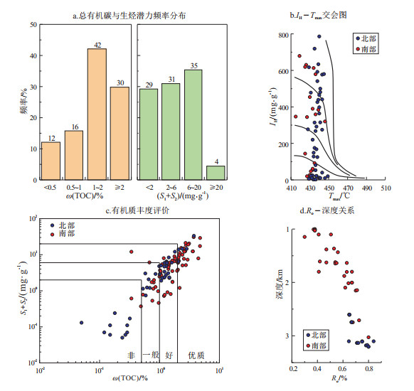
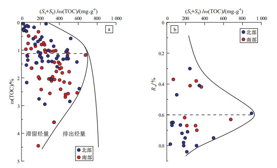
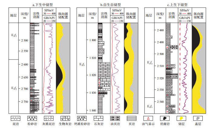
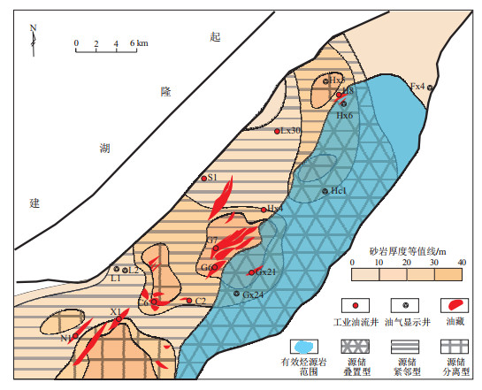
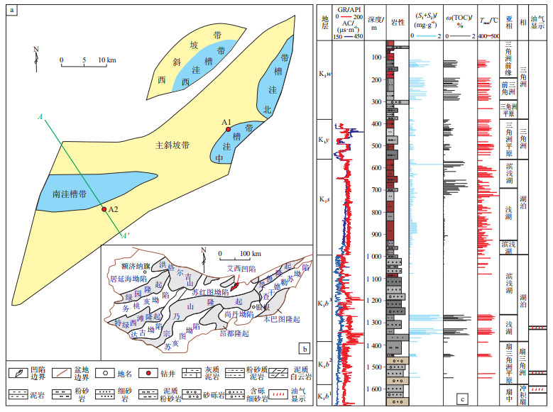
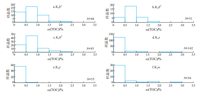
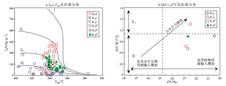
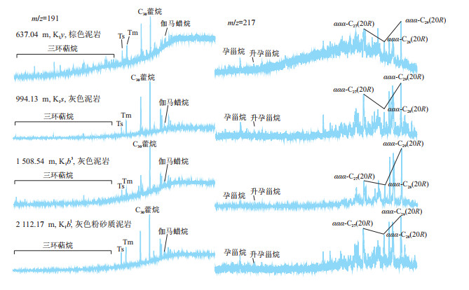
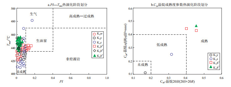
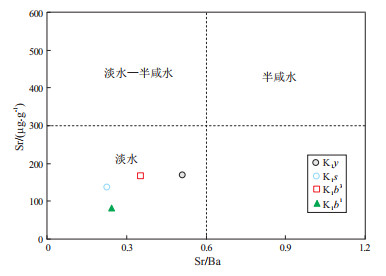
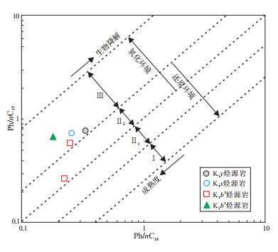
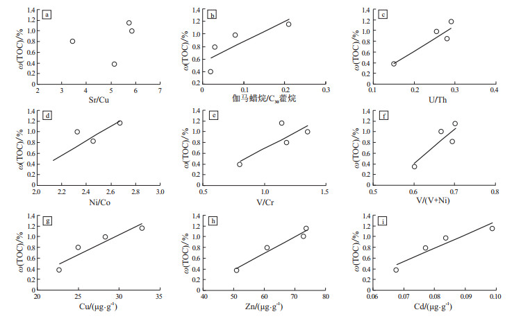
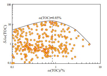
Geochemical characteristics and resource potential of source rocks in Aixi Sag, Yingen-Ejinaqi Basin
ZHANG Yaxiong, CHEN Zhijun, GAO Yiwen, WANG Xiaoduo, HAN Changchun, LI Ziliang
2022, 44(6): 1048-1058. doi: 10.11781/sysydz2022061048
Abstract(286) HTML (106) PDF-CN(50)
Abstract:
In order to clarify the source rock conditions and oil/gas potential of the Aixi Sag in the Yingen-Ejinaqi Basin, based on the analytical results of mudstone samples from two exploratory wells, a systematic evaluation of the source rocks was carried out in this paper, and the effective source rocks were supposed. The potential source rocks in the study area are mudstones developed in Cretaceous Wulansuhai Formation (K2w), Yingen Formation (K1y), Suhongtu Formation (K1s), and the third (K1b3), second (K1b2) and first member (K1b1) of Bayingebi Formation, among which the K1b3, K1b2 and K1b1 mudstones have the highest abundance of organic matter with the kerogen types of Ⅱ-Ⅲ at mature stages of thermal evolution. Elemental geochemical and biomarker data show that the paleoclimate during the deposition of source rocks was warm and humid, the sedimentary water was mainly fresh water, and the contribution of terrestrial organic matter was dominant. The favorite sedimentary paleoenvironment conducive to organic matter enrichment is high salinity and strong reducibility, and high productivity is the main controlling factor for the enrichment of organic matter. The lowest limit of TOC content of effective source rocks is supposed to be 0.85%, and the effective source rocks are mainly developed in K1b3, K1b2 and K1b1. They are mainly distributed in considerable areas in the southern, central, northern and western subsags. The total oil and gas resources in the study area are estimated to be around 5 091.05×10⁴ t. Combined with the evidence of active oil and gas display, it is concluded that the study area has good oil and gas exploration potential.
Biomarker compositions and geochemical significance of crude oils of Baiyun Sag, Pearl River Mouth Basin
RAN Zichao, LI Meijun, LI Youchuan, SHI Yang, WANG Ning, YANG Yongcai, LU Xiaolin, XIAO Hong
2022, 44(6): 1059-1069. doi: 10.11781/sysydz2022061059
Abstract(420) HTML (137) PDF-CN(70)
Abstract:
Crude oils from the Baiyun Sag of Pearl River Mouth Basin have high abundance of diagnostic biomarkers including novel C15 sesquiterpene, special configurated tricyclic sesquiterpenes and tetracyclic sesquiterpenes (X, Y, Z and X1, Y1, Z1), and bicadinanes, which indicate the contributions from terrestrial higher plants to the organic matters. These oils are also rich in oleanane, which is a diagnostic biomarker for angiosperm organic matter. Based on the analysis of 13 crude oils from the Baiyun Sag, the compositions and geochemical significance of typical biomarkers were revealed. Results indicate that C24-des-oleanane (Y1) and C27 tetracyclic (Z1) may share a similar biological origin. Novel C15 sesquiterpene, C24-des-oleanane and C27 tetracyclic, and bicadinanes may be derived from different higher plants according to the molecular structure and abundance correlation analysis of the related compounds. In addition, the biomarker compositions of crude oils from different regions are significantly varied, which will benefit the oil group classification in the Baiyun Sag. The distribution of novel C15 sesquiterpene and bicadinanes was influenced by sedimentary environment, and may be more enriched in oxidized environment. The distribution patterns of C24-des-oleanane, C27 tetracyclic and oleanane are principally affected by biogenic input, but are less influenced by sedimentary environment fluctuation. The relatively high abundance of C24-des-oleanane, C27 tetracyclic and oleanane in the crude oil in the northeastern and eastern Baiyun area reflects that the Dongsha Uplift and the Yunli Low Uplift may be an important source of terrigenous organic matter in this area.
Prediction of organic facies of deep source rocks in southwestern part of Bozhong Sag, Bohai Bay Basin
WANG Xiang, MA Jinfeng, WANG Feilong, WANG Zhenliang, CHEN Rongtao, YAN Xinyu
2022, 44(6): 1070-1080. doi: 10.11781/sysydz2022061070
Abstract(308) HTML (92) PDF-CN(64)
Abstract:
Considering the characteristics of abundant source rock formations and heterogeneity in the southwestern part of the Bozhong Sag, Bohai Bay Basin, based on the geochemical and petrographic analysis of source rocks, the methods of ΔlogR series, multiple regression and BP neural network are applied to predict the organic matter abundance under the constraints of sedimentary facies.The BP neural network method is preferably used to predict the total organic carbon content and cracked hydrocarbon content of source rocks in a single well, and then the hydrogen index prediction curve is calculated.Combined with total organic carbon content, the organic phase of each source rock layer is quantitatively described, and the advantages and disadvantages and distribution characteristics of source rocks are analyzed. Results show that the prediction accuracy of BP neural network method is relatively higher. The source rocks in the lower section of the second member of Dongying Formation are featured by kerogen of type Ⅱ2, hydrocarbon index of 125-400 mg/g, TOC content basically less than 3%, and organic facies of BC, C and CD types. The source rocks in the third member of Dongying Formation are featured by kerogen of typesⅡ1 to Ⅱ2. The source rocks in the first, second and third members of Shahejie Formation are featured by kerogen of types Ⅰ to Ⅱ1, TOC content about 3% or higher than 3%, and organic facies of B, BC and C types.The high-quality source rocks of the Shahejie Formation are mainly developed in the central and southern parts of the study area, and are the key areas for further exploration.
Play risk evaluation for hydrocarbon exploration
LIU Zengqin, LÜ Rui
2022, 44(6): 1081-1087. doi: 10.11781/sysydz2022061081
Abstract(1334) HTML (75) PDF-CN(76)
Abstract:
Risk and uncertainty are coherent attributes in hydrocarbon play exploration, and comprehensive exploration strategy requires a deliberate consideration of risk aversion and an faithful understanding of uncertainty. According to the characteristics of SINOPEC oversea oil and gas exploration projects, as well as the exploration project evaluation criteria of international oil companies, this paper describes the establishment of value-determined standards and hydrocarbon play risk workflow by quantitative assessment of hydrocarbon generation and charge capability, reservoir quality, preservation condition, and trap validity of a play. According to data density, coverage and geological understanding, in accordance with bucket theory, the probabilities of occurrence of four risk factors were determined, and the chance of geologic success (COGS) of a play was obtained by multiplying the probabilities of each risk factor. This workflow provided a method for transferring qualitative geological understanding and exploration data to quantitatively assess the risk probability of each factors and overall COGS. The COGS values determine the play risk, which is a comprehensive reflection of the exploration phase and geological characteristics of the study block. The play risk workflow facilitates high grading areas, allows a focus on the exploratory and appraisal aspects, and provides a scientific basis for exploration investment decision.
Method of post-drilling assessment for the prospect evaluation of petroleum exploration
WANG Yigang, SHENG Xiujie, YANG Shuang, CAO Jin
2022, 44(6): 1088-1091. doi: 10.11781/sysydz2022061088
Abstract(413) HTML (158) PDF-CN(71)
Abstract:
Post-drilling evaluation is an important part of prospect evaluation in the oil and gas exploration processes. With the comparative analysis of pre-drilling prediction and post-drilling results, the experience is summarized, and the deficiencies in pre-drilling evaluation and prediction are corrected and improved, so that the pre-drilling evaluation and prediction results of exploration targets are more accurate, and the success rate for the coming oil and gas exploration can be improved. Based on introducing the main contents and methods of post-drilling evaluation, the problems and solutions that need to be focused on in post-drilling evaluation are summarized in this paper. By analyzing the geological risk factors and reserve parameters of both successful and failed drilling, the key elements of large deviation between pre-drilling prediction and post-drilling estimation are compared, and the causes for the deviation are discussed and improved, which can be helpful on improving the geological explorers' ability of prediction and enhancing the success ratio of exploration in the following work.
Experimental study on the mobility of Junggar Basin's Jimsar shale oil by CO2 huff and puff under different temperatures and pressures
WANG Ziqiang, GE Hongkui, GUO Huiying, ZHOU Hao, ZHANG Yuankai
2022, 44(6): 1092-1099. doi: 10.11781/sysydz2022061092
Abstract(233) HTML (101) PDF-CN(49)
Abstract:
Micro- and nano-scale pore-throat fissure systems were mainly developed in the Jimsar shale oil reservoir of the Junggar Basin with the oil of viscous and difficult to be produced.CO2 huff-and-puff is an important technology to enhance the oil recovery. To understand the mobility law of Jimsar shale oil reservoir under CO2 huff and puff, 45 cores of the Lucaogou Formation in this area were studied in this study.The cores was classified into dolomitic sandstone, doloarenite and lithic sandstone. The overburden porosity of the reservoir is 2.0%-22.7%, and the average value is only 11.0%. The average overburden permeability is 0.01×10⁻³ μm2, and more than 90% of the samples have permeability lower than 0.1×10⁻³ μm2. According to physical property classification, 20 rock samples were further selected and 6 key parameters for low-field NMR measurement were optimized. By comparing the experimental data of shale oil mercury injection with those of low-field NMR, the linear relationship between T2 value and pore radius of shale core was established in logarithmic coordinates.The pore radius distribution of shale was obtained quantitatively according to the T2 spectrum. 9 kinds of CO2 huff and puff experiments were carried out under different temperatures and pressures. The analyses of recovery rate, utilization degree and other indicators show that shale oil in small pores(r < 300 nm) is difficult to produce, and the utilization degree of shale oil in medium pores (300 nm < r < 1 000 nm) and large pores(r>1 000 nm) is relatively higher, and increases with the increase of temperature and pressure.
Evaluation method for uncertain potential of undeveloped reserves
FAN Yumei
2022, 44(6): 1100-1104. doi: 10.11781/sysydz2022061100
Abstract(177) HTML (59) PDF-CN(34)
Abstract:
Retained undeveloped reserves are generally low-grade and undergone multiple rounds of screening and evaluation. The reservoir is highly heterogeneous and the overall production technology is poorly matched.Therefore, the use of traditional deterministic parameters to evaluate and screen the overall potential has limita-tions and a set of evaluation method for the uncertain potential of undeveloped reserves has been constructed.In the view of local "sweet spot" potential of heterogeneous oil reservoirs, a model for controlling recoverable reserves and reservoir parameters in a single well under different technical conditions was established to calculate the "sweet spot" limit of single-well-controlled recoverable reserves under different technical and economic conditions, input the probability distribution of relevant reservoir parameters, and calculate the recoverable probability of target reservoir.The probability reflected the difficulty of reserve production, and quantitatively described the risk and scale of reserves production.The method was applied to evaluate the proved undeveloped reserves of SINOPEC. Under the oil price of 40-70 /BBL, the exploitable potential was screened as (4 300-5 900)×104 t.Field application showed that this method can provide a new reference for the evaluation and screening of undeveloped reserves.
Application of mercury intrusion method and digital image analysis in quantitative analysis of micro-scale pores in tight sandstone reservoirs: a case study of X block in Wuqi Oil Field, Ordos Basin
SUN Yaxiong, ZHANG Tan, DING Wenlong, YAO Wei, ZHANG Chi
2022, 44(6): 1105-1115. doi: 10.11781/sysydz2022061105
Abstract(212) HTML (80) PDF-CN(52)
Abstract:
In order to investigate the pore structures of the tight sandstone reservoirs in the 4+5th and 6th members of the Triassic Yanchang Formation (Chang4+5 and Chang6, respectively), and the 9th and 10th members of the Jurassic Yan'an Formation (Yan9 and Yan10, respectively) in the X block of Wuqi Oil Field, Ordos Basin, 12 samples were collected to analyze reservoir properties with the approaches of scanning electron microscope observation, X-ray diffraction and high pressure mercury intrusion. We also quantitatively characterized the pore parameter and fractal dimension of the tight sandstones by the using of digital image analysis and fractal geometry. In addition, we discussed the relationship between fractal dimension and sample properties (porosity, permeability), pore structure parameter (average pore-throat radius, sorting coefficient), pore geometric parameters (dominant pore size, perimeter over area, and pore body-to-throat ratio). The influence of sedimentary facies and diagenetic environment on pore structures were also quantitatively analyzed. Results show that the pore structure fractal dimension ranges from 2.164 to 2.895, with an average value of 2.395. Fractal dimension is negatively correlated to permeability, porosity and average pore-throat radius, and positively related to sorting coefficient. Tight sandstones in the study area generally show properties of low dominant pore size, high perimeter over area, lower body-to-throat ratio, and high dimensions. The fractal dimension is positively related to body-to-throat and perimeter-to-area ratio, and negatively related to pore size. It is indicated that the pore structure of the samples is relatively complex and has strong heterogeneity. Depositional environment affects the compositional maturity and structural maturity of reservoir.
Discussion on integrated geological and geophysical identification method for spatial distribution of favorable source rocks in depression with lack of drilling data: a case study of Enping 17 Sag, Zhu Ⅰ Depression, Pearl River Mouth Basin
PENG Guangrong, LONG Zulie, SHI Yuling, SHI Chuang, YANG Xingye, LIU Ling, MA Xiaonan
2022, 44(6): 1116-1122. doi: 10.11781/sysydz2022061116
Abstract(205) HTML (92) PDF-CN(38)
Abstract:
Due to the lack of drilling data in the Zhu 1 Depression of the Pear River Mouth Basin, the Enping 17 Sag is taken as an example in this paper to solve the problem of comprehensive identification of underground distribution of high-quality source rocks. Based on the analysis of the geological background, sedimentary characteristics and petrophysical characteristics of source rocks, seismic inversion is guided by the constraints of the petrophysical characteristics of the source rocks in different sedimentary environments. According to the statistics of the relationship between the lithofacies of drilled source rocks and the inversion resistance, a semi-quantitative prediction of the spatial distribution of favorable source rocks is made by geological modeling, and the rationality of prediction method and results is analyzed in combination with the recognition of the geochemical origin type and source of crude oil, to discuss the geological and geophysical identification method of the underground distribution of high-quality source rocks with lack of drilling data. The more reductive the depositional environment of source rocks in the Paleogene Wenchang Formation, the lower the impedance value of high-quality source rocks, and the greater the impedance difference between poor source rocks or non-source rocks. The third, fourth and fifth members of Wenchang Formation are the main source rocks of the Enping 17 Sag, which can be supported by the study of crude oil biomarkers. In the small sags of the Pearl River Mouth Basin with basically clear petroleum geological background conditions, establishing the quantitative and semi-quantitative relationship between the lithofacies of source rocks and the inversion impedance value is helpful to quickly clarify the development interval and scale of main source rocks. This method has a good prospect of popularization and application.
2022, 44(6): 1123-1123.
Abstract:
2022, 44(6): 1124-1124.
Abstract:
2022, 44(6): 1125-1134.
Abstract: